
|
Home | Docs | Issue Tracker | FAQ | Download |
|
|
| Author: | Tamas Szekeres |
|---|---|
| Contact: | szekerest at gmail.com |
| Author: | Jeff McKenna |
| Contact: | jmckenna at gatewaygeomatics.com |
| Last Updated: | 2011-04-11 |
Table of Contents
Since version 6.0, MapServer has the ability to display features from multiple layers (called ‘source layers’) in a single mapfile layer. This feature was added through MS RFC 68: Support for combining features from multiple layers.
This is a native MapServer option that doesn’t use any external libraries to support it.
Note
You may wish to disable the visibility (change their STATUS) of the source layers to avoid displaying the features twice.
For example:
LAYER
  NAME "union-layer"
  TYPE POINT
  STATUS DEFAULT
  CONNECTIONTYPE UNION
  CONNECTION "layer1,layer2,layer3" # reference to the source layers
  PROCESSING "ITEMS=itemname1,itemname2,itemname3"
  ...
END
LAYER
  NAME "layer1"
  TYPE POINT
  STATUS OFF
  CONNECTIONTYPE OGR
  CONNECTION ...
  ...
END
LAYER
  NAME "layer2"
  TYPE POINT
  STATUS OFF
  CONNECTIONTYPE OGR
  CONNECTION ...
  ...
END
LAYER
  NAME "layer3"
  TYPE POINT
  STATUS OFF
  CONNECTIONTYPE OGR
  CONNECTION ...
  ...
END
In the LAYER definition you may refer to any attributes supported by each of the source layers. In addition to the source layer attributes the union layer provides the following additional attributes:
During the selection / feature query operations only the ‘Combine:SourceLayerName’ and ‘Combine:SourceLayerGroup’ attributes are provided by default. The set of the provided attributes can manually be overridden (and further attributes can be exposed) by using the ITEMS processing option (refer to the example above).
We can define the symbology and labelling for the union layers in the same way as for any other layer by specifying the classes and styles. In addition the STYLEITEM AUTO option is also supported for the union layer, which provides to display the features as specified at the source layers. The source layers may also use the STYLEITEM AUTO setting if the underlying data source provides that.
For speed, it is recommended to always use the same projection for the union layer and source layers. However MapServer will reproject the source layers to the union layer if requested. (for more information on projections in MapServer refer to PROJECTION)
The following processing options can be used with the union layers:
UNION_SRCLAYER_CLOSE_CONNECTION=ALWAYS
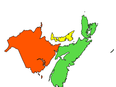
The follow example contains 3 source layers in different formats, and one layer (yellow) in a different projection. The union layer uses the STYLEITEM “AUTO” parameter to draw the styles from the source layers. (in this case MapServer will reproject the yellow features, in EPSG:4326, for the union layer, which is in EPSG:3978).

MAP
...
PROJECTION
  "init=epsg:3978"
END
...
LAYER
  NAME 'unioned'
  TYPE POLYGON
  STATUS DEFAULT
  CONNECTIONTYPE UNION
  CONNECTION "red,green,yellow"
  STYLEITEM "AUTO"
  # Define an empty class that will be filled at runtime from the color and
  # styles read from each source layer.
  CLASS
  END
  PROJECTION
    "init=epsg:3978"
  END
END

LAYER
  NAME 'red'
  TYPE POLYGON
  STATUS OFF
  DATA 'nb.shp'
  CLASS
     NAME 'red'
     STYLE
       OUTLINECOLOR 0 0 0
       COLOR 255 85 0
     END
  END
END

LAYER
  NAME 'green'
  TYPE POLYGON
  STATUS OFF
  CONNECTIONTYPE OGR
  CONNECTION 'ns.mif'
  CLASS
     NAME 'green'
     STYLE
       OUTLINECOLOR 0 0 0
       COLOR 90 218 71
     END
  END
END

LAYER
  NAME 'yellow'
  TYPE POLYGON
  STATUS OFF
  CONNECTIONTYPE OGR
  CONNECTION 'pei.gml'
  CLASS
     NAME 'yellow'
     STYLE
       OUTLINECOLOR 0 0 0
       COLOR 255 255 0
     END
  END
  PROJECTION
    "init=epsg:4326"
  END
END

END # Map
<?php

// open map
$oMap = ms_newMapObj( "D:/ms4w/apps/osm/map/osm.map" );

// create union layer
$oLayer = ms_newLayerObj($oMap);
$oLayer->set("name", "unioned");
$oLayer->set("type", MS_LAYER_POLYGON);
$oLayer->set("status", MS_ON);
$oLayer->setConnectionType(MS_UNION);
$oLayer->set("connection", "red,green,yellow");
$oLayer->set("styleitem", "AUTO");
$oLayer->setProjection("init=epsg:3978");
// create empty class
$oClass = ms_newClassObj($oLayer);
...

?>